|
Streamflow Management SystemDepartment of Public Works and Highways - Bureau of Design - Water Projects Division |
|
|
Streamflow Management SystemDepartment of Public Works and Highways - Bureau of Design - Water Projects Division |
March, 2016

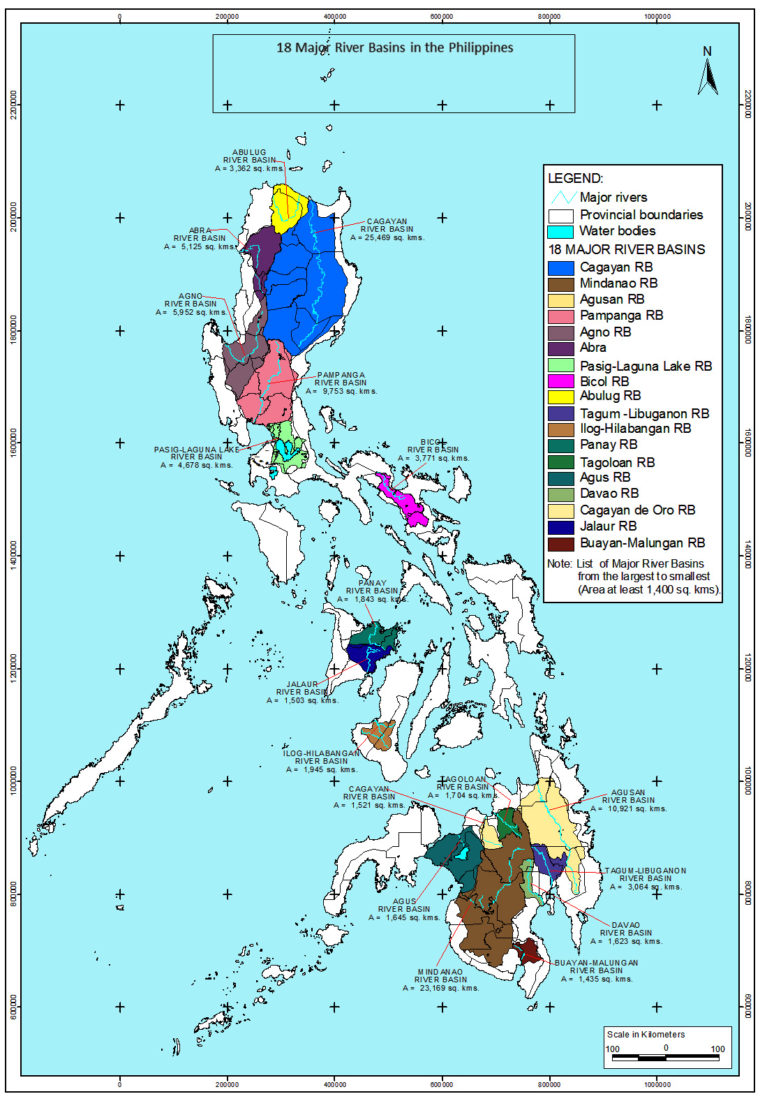
The National Hydrologic Data Collection Program (NHDCP) intends to collect process and manage streamflow data sets for flood control design, water allocation, and water resources planning.
The Bureau of Design - Water Projects Division (BOD-WPD) of the Department of Public Works and Highways (DPWH) is tasked to coordinate with relevant agencies to formulate policies and plans for the program's implementation. BOD-WPD will lead the collection, management, evaluation and processing of streamflow data. The mean discharges from the processed streamflow data will be published to a platform available to users and various stakeholders.
Current and historical streamflow records must be intact to aid DPWH and other agencies in the following aspects:

FLOOD CONTROL AND MANAGEMENT
The historical data sets are vital to the design of flood control infrastructures and other structures that mitigate risks from water-related hazards.

RESOURCE REGULATION
The generated water level and discharge is the basis for allocation of water uses for hydropower, irrigation and domestic water supply by the National Water Resources Board (NWRB).
WATER RESOURCES PLANNING
A robust national streamflow data is crucial to the preparation of water resources development plans, local disaster risk profiling of communities, and community flood mitigation planning. It also aids the national government in developing programs and policies to achieve water security.
With support from the United States Agency for International Development (USAID) Water Security for Resilient Economic Growth and Stability (Be Secure) Project, a technical assistance program was created that will transform the current stream flow data sets into readily available and manageable formats.
Five (5) pilot regions have been identified (Region 6, Region 8, Region 9, Region 10 and Region 12), where streamflow data were acquired and digitized. A platform that will generate actual discharge measurements was established through information communication technology (ICT). The initiative also capacitated the DPWH-BOD staff in collecting, processing and evaluating streamflow information, and drawing up long-term plans for the NHDCP.
A Technical Working Group (TWG) was created composed of representatives from DPWH BOD-WPD, DPWH-Information Management System, National Irrigation Administration, National Water Resources Board, and Local Water Utilities Administration. The TWG will function as counterpart of USAID Be Secure Project's consultants from Haskoning Philippines Inc. and Woodfields Consultants, Inc. for the digitization of streamflow data.
1. Collect & Submit
Regional Quality Assurance and Hydrology Division (QAHD) Offices collect water level and discharge measurements data for entry to "StreaMS". BOD validates the collected field data for processing and evaluation.
2. Process/Evaluate
Update existing rating curve using validated field data. In the event that there is no established rating curve yet, a new rating curve shall be developed.
Convert stage (water level) information to river discharge. Use output for Flood Frequency and Flow Duration Analyses.
3. Publish
Make data available from "StreaMS" website such as daily, monthly, annual, extreme discharge values, and other streamflow data analyses.
4. Utilize
Apply and use published information for future endeavors in flood control management, as well as water resources planning and regulation.
This is made possible through the generous support of the American people through